Looking at the map, it’s easy to see that there are many natural spaces close to San Diego like Anza-Borrego or Torrey Pines State Parks. But since it was National Parks Week, I chose Joshua Tree National Park (JOTR) for my Spring in SoCal Roadtrip, a three and a half hour drive from where I was in Point Loma. I considered this my first visit to the park. I’d been through it as a child since we lived in nearby Arizona, but at that time, I didn’t appreciate the trees’ tenacity or the deserts’ dusty decadence.

If you have heard of Joshua Tree for any reason other than as a special plant, it’s likely for music. Legend has it that the band U2 holed up in the Harmony Motel to complete the album later to be called, well, not Zooropa. Harmony Motel is in the town of Twentynine Palms. Led Zeppelin’s now solo Robert Plant wrote a song called “29 Palms,” ostensibly about the town but rumored to be inspired by “Black Velvet” songstress Alannah Myles.

Because of my other trip obligations (I had to get back for an oceanside champagne brunch), I had twenty-one hours total to get to the park and back to Point Loma. JOTR could be a day trip from San Diego or Las Vegas, but I recommend staying overnight. I enjoyed the beautiful drive from San Diego to Twentynine Palms, around Mount San Jacinto and through the Morongo Valley. I was fearful of traffic because it also happened to be Coachella Music Festival in Indio, about 30 minutes southwest. I guess Coachellans took a different route because I didn’t encounter a single stop or slowdown… except when I needed an In-And-Out burger fix, of course.

There are three entrances to Joshua Tree National Park. When I stopped at the California Welcome Center in the town of Yucca Valley, the expert there recommended bypassing the Joshua Tree/West entrance where there may be a line. So I used the Twentynine Palms/North entrance instead, and it was very easy to find with absolutely no line.

I started my tour of JOTR by heading up to Keys View to see the San Andreas fault (it’s visible in person from the view shown above, but the haze/pollution as noted in the sign above obscured the photo). It was very windy on this little trail though, gusts over 50 MPH, I would guess. After nearly a decade of life in Wyoming, I consider myself qualified to guess-timate windspeed. But then I recalled the massive wind farm I passed along the way, so I could not be surprised. This is why, even when packing for a spring trip to the beach and desert, I brought a jacket. And a comb.

There was also a sign here warning of killer bees. I will admit that I didn’t understand the sign at first. It was near some restrooms, so I thought it was warning about flies! Who makes a warning sign about bees without stingers? Some research upon my return revealed that there have been issues with Africanized honey bees at this park as with many U.S. desert locales. This is a serious issue, and you need to know what to do if attacked by killer bees. Basically: RUN. But take comfort in knowing that, “the average adult could withstand more than 1100 stings” according to that USDA link. Oh my goodness. I am terrified of bees in general, let alone this aggressive version. Fortunately twice here though: there did not appear to be bees out, perhaps because of the wind. Secondly, this info was good to have in advance of a trip I later took to Arizona where people have died from attacks.

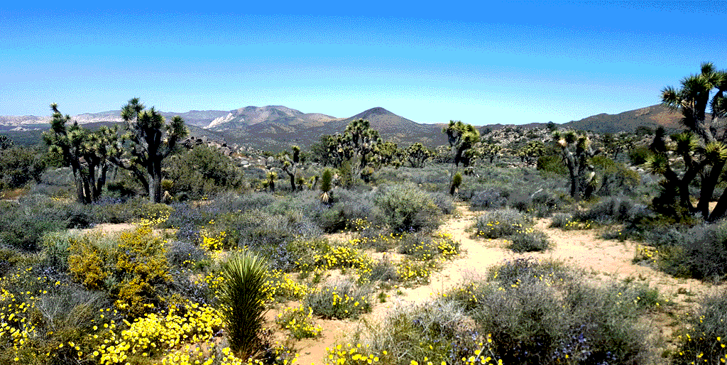
Elsewhere in the park, there were several trail options to consider, and I chose Hidden Valley, above, in part because there was a parking spot at that lot. The one mile loop hike started off with some really useful signage to help users learn more about the floral and fauna diversity and challenges. Across the road is Barker Dam, which is currently closed to restore the rocks from graffiti vandalism. Learn more about the restoration by watching this video by The Desert Sun newspaper, then learn more about vandals who get caught in the article below it.

Please do not mess with the trees or harm their habitat. Visit, but tread lightly. Take only pictures, and leave only footprints. Otherwise, pictures will be all that we have left of these tenacious trees which have managed to survive in this harsh desert habitat but still cannot survive thoughtless vandals.

My time in JOTR was most magical as the sun was setting. The silhouettes of the wild and almost woolly trees really stand out against a golden sky.

I can’t help wondering if Dr. Seuss/Theodor Geisel was inspired by these trees to illustrate his books. This species of yucca thrives where most plants could not, and it does so because of the seemingly-haphazard way the branches grow. This sign called it, “The Adventurous Yucca.” Sometimes that’s what we have to do — make a new path if that’s what it takes to survive or even thrive.

JOTR is placed where two distinctive deserts meet, the Mojave and the Sonoran. As I mentioned, I lived nearby in the Mojave desert as a kid, so as I continue my journey in a larger sense, exploring “home,” I wanted to revisit. It seemed special to be on the edge of two such grand spaces of the American Southwest.

Drive beyond White Tank campground and trail, through Wilson Canyon to the Cholla Cactus Garden, and you will be in this transitory space. The joshua trees dissipate and the cholla cacti begin. A boardwalk guides visitors through the densely populated garden of these cacti, and rightfully so. Although nicknamed “teddy bear cacti,” they are neither soft nor cuddly.

Although JOTR extends farther from this mercurial border, something told me to stop there at the Cholla Cactus Garden and just keep this jaunt about the Mojave. Little did I know how soon I would be exploring the Sonoran more fully. But that is another blog post in the Desert Mystique series…

Join the conversation @trailheaders @JoshuaTreeNPS #FindYourPark
Your voice matters!